Description
Explore the stunning Norwegian coastline with confidence using the Garmin Navionics Vision+ NVEU051R marine chart. This premium cartography transforms your Garmin chartplotter into a powerful navigation ally, blending cutting-edge details with intuitive tools tailored for the rugged waters from Lista to Sognefjord. Whether you’re a seasoned skipper maneuvering through narrow fjords or an angler hunting prime fishing grounds near Bergen, this chart delivers precision that keeps you safe and informed.
Detailed Coverage for Norway’s Iconic Waters
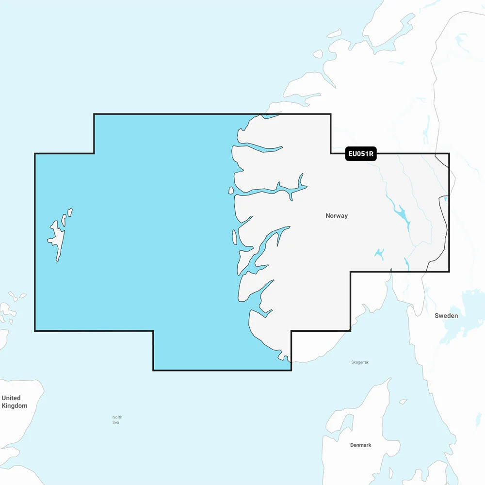
Spanning from Farsund’s southern shores up to Maløy, the NVEU051R chart captures every twist and turn of the Norway coast. Dive into intricate details of key hubs like Bergen, Haugesund, and Stavanger, plus extended views of the Shetland Islands and the majestic Sognefjord. This coverage isn’t just lines on a screen—it’s a virtual pilot’s eye view, highlighting channels, harbors, and hidden coves that make Norwegian boating unforgettable.
Boaters rave about how this chart reveals submerged rocks and shifting sands in areas prone to strong currents, helping you avoid surprises during tidal changes common in these northern latitudes.
Standout Features That Elevate Your Boating Experience
- All-in-One Mapping Power: Seamlessly switch between coastal, inland, lake, and river views. Garmin’s integration with Navionics content means global coverage at your fingertips, perfect for multi-leg voyages.
- Daily Updates via ActiveCaptain: Stay ahead of changes with thousands of daily enhancements. Your one-year subscription ensures your charts reflect the latest nautical intelligence from a global network of mariners.
- Auto Guidance+: Get smart, dock-to-dock routes that factor in your boat’s draft and beam. It’s like having a local guide whisper the safest path through inlets and marinas.
- Advanced Depth Shading: Customize up to 10 shaded depth ranges—ideal for pinpointing fishing honey holes or steering clear of shallows in Sognefjord’s arms.
- Ultra-Fine Contours: Down to 1-foot intervals, these reveal bottom structure for trophy fishing or precise anchoring in Bergen’s busy bays.
- Shallow Water Highlighting: Set your own depth threshold to visually flag risks, a lifesaver in unfamiliar Norwegian waters.
- Community Insights: Tap into ActiveCaptain for real-user tips on anchorages, hazards, and top spots from fellow boaters who’ve navigated these waters.
- Premium Visuals: Overlay high-res satellite images, aerial photos, and 3D views like Fisheye (underwater) or Marinereye (above and below) for unmatched situational awareness.
- Lake Level Adjustments: Fine-tune maps for current water levels in inland sections, ensuring accessible routes.
These tools go beyond basic charts, empowering you to fish smarter, navigate bolder, and explore deeper into Norway’s dramatic landscapes.
Real-World Applications for Norwegian Boaters
Picture threading through Stavanger’s fjord entrances at dusk, with Auto Guidance+ lighting the way past rocky outcrops. Or targeting cod runs off Lista, where 1-foot contours expose drop-offs teeming with life. Families cruising to the Shetlands appreciate the aerial photography for spotting distant landmarks, while commercial operators in Haugesund rely on community POIs for reliable services. This chart adapts to your adventure, from casual day trips to epic coastal hauls.
Seamless Integration with Garmin Devices
Designed for plug-and-play simplicity on microSD/SD cards, it pairs effortlessly with compatible Garmin chartplotters. Verify your model’s support to unlock every feature, ensuring smooth updates and vivid displays on the water.
Frequently Asked Questions
What specific areas does the Garmin Navionics Vision+ NVEU051R cover?
It provides detailed coverage of the Norway coast from Farsund (near Lista) to Maløy, including the Shetland Islands, Sognefjord, and cities like Bergen, Haugesund, and Stavanger.
What subscription comes with the NVEU051R chart?
A one-year subscription to daily chart updates through the ActiveCaptain app is included, keeping your maps current with the latest enhancements.
How does Auto Guidance+ work on this marine chart?
It generates suggested dock-to-dock routes based on your vessel specs, navigating channels, inlets, and marinas—always use it alongside safe boating practices.
Can I customize depth shading for fishing with NVEU051R?
Yes, select up to 10 color-shaded depth ranges to highlight prime fishing depths, plus shallow water shading for hazard avoidance.
What 3D views are available in this chart?
Fisheye View offers an underwater 3D perspective of contours, while Marinereye combines above- and below-waterline details for comprehensive awareness.
Is high-resolution satellite imagery included?
Yes, downloadable high-res satellite overlays and aerial photos enhance navigation around ports, marinas, and landmarks.
How do I access community content with this chart?
Through the ActiveCaptain community, get user-shared POIs like marinas, anchorages, and hazards from experienced local boaters.
Navionics Vision+ NVEU051R – Norway, Lista to Sognefjord – Marine Chart
Get the world’s No. 1 choice in the marine mapping with the best, most up-to-date Navionics®+ cartography on your compatible chartplotter.
Featuring vibrant colors, a streamlined interface and combined coastal/inland content with a popular Navionics® style color palette, Garmin Navionics+ cartography makes it easy to plot your course. Multiple shading options aid in shallow water navigation and make it easy to highlight a target depth range for the best fishing spots. Fully customizable with various chart layers, overlay combinations and up to 10 color-shaded target depth ranges to scope out the best fishing spots.
When you purchase a new Garmin Navionics+ or Garmin Navionics Vision+ cartography product, a one-year subscription is included.
Chart Code – NVEU051R
Coverage Area:
Detailed coverage of the Norway coast from Farsund to Maloy, including the Shetland Islands and the Sognefjord. Includes detailed coverage of Bergen, Haugesund and Stavanger.
Features:
- All-in-one Map Solution – Access detail-rich mapping of coastal features, lakes, rivers and more. Integrated Garmin and Navionics® content offers coverage for boaters worldwide.
- Daily Chart Updates – Charts are constantly being enhanced with new and amended content — as many as 5,000 updates are made every day. The one-year included subscription gives you access to daily chart updates via the ActiveCaptain app.
- Auto Guidance+ Technology – Combining the best of Garmin and Navionics automatic routing features, built-in Auto Guidance+ technology1 gives you a suggested dock-to-dock path to follow through channels, inlets, marina entrances and more.
- Depth Range Shading – High-resolution depth range shading lets you select up to 10 color-shaded options and view your designated target depths at a glance.
- Up to 1′ Contours – For improved fishing and navigation, up to 1′ contours provide a clear depiction of bottom structure for improved fishing charts and enhanced detail in swamps, canals, harbors, marinas and more.
- Shallow Water Shading – To give a clear picture of shallow waters to avoid, this feature allows for shading at a user-defined depth.
- ActiveCaptain Community – Community-sourced content provides useful POIs, such as marinas, anchorages, hazards, businesses and more. Get recommendations from boaters with firsthand experience of the local environment.
- High Resolution Satellite Imagery – Downloadable high-resolution satellite imagery provides superior situational awareness.
- Aerial Photography – Crystal-clear aerial and surface photos of ports, marinas, bridges, docks, boat ramps, dams and navigational landmarks provide a better sense of your surroundings above the waterline.
- 3D Fisheye View – This underwater perspective shows 3D representation of bottom and contours as seen from below the waterline. Interface with sonar data for a customized view.
- 3D Marinereye View – This view provides a 3D representation of the surrounding area both above and below the waterline.
- Dynamic Lake Level – Adjust your maps to the lake’s current water levels to see if spots are accessible or too shallow to explore.
Compatibility:
- Check the compatibility of Garmin Navionics+ content and features with your GPS chartplotter.
Technical Specifications:
- Format – MicroSD/SD Card
In the Box:
- SD/MSD Card
1Auto Guidance+ is for planning purposes only and does not replace safe navigation operations
*Sold as an Individual
SKU: NVN-96380
MPN: 010-C1250-00
UPC:
Reviews
There are no reviews yet.