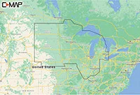
Description
Cruising, fishing or sailing, C-Map Reveal Lakes charts offer the very best of C-MAP. With shaded relief, including game-changing reveal seafloor imagery, aerial photography and satellite overlay presentation added to the core C-Map features found in discover – full-featured vector charts, with custom depth shading and subscription-free easy routing. It also includes the very best of C-Map high-res bathymetric, including integrated genesis data. Purchase includes a full 12 months of online updates.


Reviews
There are no reviews yet.